Fort Nelson Demonstration Forest Recreation Site 434 m
Forecast
Snow over the next 7 days at the resort height, by model: GFS 0.1 cm · ECMWF 0.3 cm · AIFS 0.3 cm.
Tap or click a day to see it hour by hour (Snowfall ).
Nothing here counts as snow: the most any day reaches is 0.22 cm.
The percentage under each day is the chance of snow: how many of the 31 ensemble members produce at least 1 cm . A low number under a day with no bar means almost every run shows no snow; a high one means most runs do. It measures how much the runs agree, not how certain the forecast is. Bars run light to dark from the resort up to the top lift; rain is only drawn when there is some.
31 runs of the American model (GFS), started from slightly different data, looking two weeks ahead. How much they disagree shows as the faint band on the temperature chart and the band on the freezing level chart (narrow means the forecast is worth trusting), and as the percentage under each day on the snowfall chart (high means most runs agree there is snow). Week 2 is shaded: by then the runs have usually spread so far apart that only the trend is worth reading — is it turning colder, is the freezing level coming down — not the numbers for a particular day.
Modelled on the 06z run (Thu 29 Oct, 06:00 UTC). The next run should reach this page around 17:42 Fort Nelson time. A newer run (12z, Fri 20 Nov) exists, but the refresh did not complete yet.
Each line is the average of the 31 runs at that height. The faint band behind the line is where the middle 80% of those runs sit: the wider it is, the less the runs agree. The week ahead is running about 2 °C above the 1991–2020 average for the date.
About the freezing level
When the band drops below the resort line, precipitation is falling as snow in the village. Model grid elevation here is 434 m.
Tap or click a day to see it hour by hour (Snowfall ).
Nothing here counts as snow: the most any day reaches is 0.42 cm.
The percentage under each day is the chance of snow: how many of the 51 ensemble members produce at least 1 cm . A low number under a day with no bar means almost every run shows no snow; a high one means most runs do. It measures how much the runs agree, not how certain the forecast is. Bars run light to dark from the resort up to the top lift; rain is only drawn when there is some.
51 runs of the European model (ECMWF) — another independent ensemble. Read week 2 against the GFS tab: when they lean the same way the trend is worth far more than either on its own, and when they disagree, nobody really knows yet. Week 2 is shaded here for the same reason.
Modelled on the 06z run (Thu 29 Oct, 06:00 UTC). The next run is due about now, so these numbers may change shortly. A newer run (06z, Fri 20 Nov) exists, but the refresh did not complete yet.
Each line is the average of the 51 runs at that height. The faint band behind the line is where the middle 80% of those runs sit: the wider it is, the less the runs agree. The week ahead is running close to the 1991–2020 average for the date.
Tap or click a day to see it hour by hour (Snowfall ).
Nothing here counts as snow: the most any day reaches is 0.54 cm.
The percentage under each day is the chance of snow: how many of the 51 ensemble members produce at least 1 cm . A low number under a day with no bar means almost every run shows no snow; a high one means most runs do. It measures how much the runs agree, not how certain the forecast is. Bars run light to dark from the resort up to the top lift; rain is only drawn when there is some.
51 runs of ECMWF's AI-based model (AIFS) — another independent ensemble. Read week 2 against the GFS tab: when they lean the same way the trend is worth far more than either on its own, and when they disagree, nobody really knows yet. Week 2 is shaded here for the same reason.
Modelled on the 06z run (Thu 29 Oct, 06:00 UTC). The next run should reach this page around 19:38 Fort Nelson time. A newer run (12z, Fri 20 Nov) exists, but the refresh did not complete yet.
Each line is the average of the 51 runs at that height. The faint band behind the line is where the middle 80% of those runs sit: the wider it is, the less the runs agree. The week ahead is running about 1.5 °C above the 1991–2020 average for the date.
One line per forecast centre, each the latest run of its own model. Where they converge the outlook is settled; where they fan out, nobody knows yet. Untick any model to take it off the charts. AIFS is ECMWF's newer AI-based model; Open-Meteo doesn't publish a standalone deterministic run for it, so its line here is its ensemble's control run rather than a single model run like the other seven.
Run each line comes from: ECMWF 06z Thu GFS 06z Thu ICON 12z Thu UK Met Office 06z Thu Météo-France 00z Thu JMA 06z Thu GEM 00z Thu AIFS 12z. The oldest of these started 540 hours before the newest, so a line that looks out of step may simply be working from older information.
Nothing here counts as snow: the most model reaches is 0.7 cm. Each line adds up that model’s snowfall as the days go on, so where it ends is the total that model expects. Lines stop where each model’s run does: ECMWF, GFS and AIFS reach two weeks; JMA and GEM stop around day 10, ICON and the UK Met Office around day 7, and Météo-France after about four days. So compare lines where they overlap, not where they end.
Crust check — freeze-melt over the last week
- Likely Resort 434 m — 4 of the last 7 days thawed by day and refroze at night; the last was Mon 26 Oct. Expect a hard or breakable crust on exposed and sunny slopes.
Last snowfall
- Resort 434 m — 2.9 cm over 2 days (snow started Tue 27 Oct, last fell Wed 28 Oct, which is 23 days ago) · freezing level about 350 m, snow down to roughly 50 m
How this is worked out
Worked out from the last 14 days of model analysis, moved to each height the same way as the forecast charts, so treat amounts as estimates. A thaw is a day reaching +1 °C followed by a night at or below -1 °C, or a day of rain. Air temperature only: sun on a slope can melt snow when the air is below freezing, and shade or wind can keep it from melting when it is above, so south-facing slopes crust sooner than the figures suggest.
Pressure & cloud cover
Windy’s own animated map, centred on Fort Nelson Demonstration Forest Recreation Site. Open one below, then use the timeline at the bottom of the map to step through the next two weeks, or the layers menu inside it to switch what it’s showing.
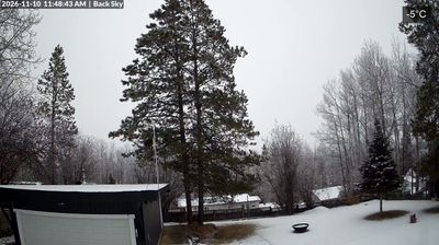
Webcams